So there are two options for climbing Mount Roland – one climbs gradually up the backside of the
mountain, the other heads straight up the face and is described on the Mount
Roland Conservation Area website as “potentially dangerous, steep and awkward.
This track is not recommended…”. Guess which one we chose?
Somewhere in amongst those cliffs is a track...
The “Face Track” starts in the forest at the base of the
mountain. I had imagined that this section wouldn’t be too bad, with the really
steep stuff starting once we hit the cliffs. This was partly right – as in the
REALLY steep stuff did start at the cliff-line, but the forest portion also
involved a pretty decent climb.
Part of the track in the bottom left of the picture
(if you think it looks almost vertical, you would be correct)
The ascent through the cliffs took us up a densely
vegetated gully, which gradually opened up towards the top of the mountain. We
alternated between ducking under and around mossy branches, to scrambling up
tumbled boulders and scree. All the while, the view behind us was growing
gradually more spectacular with the elevation gained.
Climbing up the gully
(some random guy in a green T-shirt keeps getting in all my shots...)
View back towards the coast
Scrambling up a rock-fall
(not very well demonstrated...)
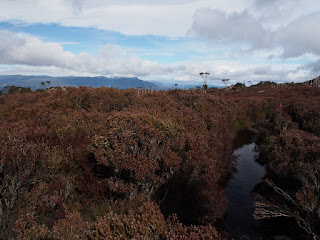
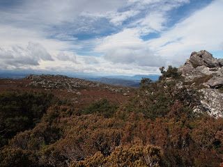
Once on top, the surroundings abruptly changed to what we’ve
come to know as “Tassie Alpine”, with low, prickly scrub dotted with jumbled
rock. We had come prepared this time with warm gear, and donned jackets,
beanies and gloves once we started finding iced over puddles along
the track.
Proof I was also there
This picturesque stream is actually the track...
Typical Tassie mountaintop
We walked for another hour or so along the plateau to
reach the trig. This involved more climbing over boulders, as well as slippery
patches of snow and lots of water and mud. The view from the trig was
magnificent with a 360° vista taking in the coastline as well as snow-capped
peaks inland. It was also freezing cold and windy (surprise), so we quickly retreated
to a lunch spot sheltered amongst the rocks below.
This is not just a picture of snow, but is actually the track
(which required a bit of rock-climbing)
Target acquired
(you can just see the tiny trig in the distance)
The view was alright I guess
(looking West-ish)
View north towards the coast
After lunch, we retraced our way back along the plateau and
then back down the gully (facing the awesome view most of the way). The descent
was unrelentingly steep (as expected) and my quads were cramping in protest by
the time we reached the bottom again.
Summary for the day – 8.5km of walking, 850m of climbing,
two very sore legs (Ryan’s were fine) and one muddy boot.
Nothing to see here


No comments:
Post a Comment