Our plan was to get up early and do some exploring in the park before it got too hot. Unfortunately, by 8.00 in the morning, it was already getting uncomfortable.


Our last stop in the park was Cockatoo Lagoon, with its promise of shade and abundant birdlife. Unfortunately it was more mud than lagoon, but there was still an assortment of ducks, geese, and brolgas to attempt to photograph.
Then we headed on into Kununurra. Our first mission was to restock the ice in our esky (turned out to be not quite up to the heat), then to find somewhere to camp for the next few nights. After a couple of laps of the main drag, we chose Kimberleyland - a caravan park on the edge of Lake Kununurra which seemed to offer the most chance of shade. Then we took off for some more exploring.
We checked out the Zebra Rock Gallery first - a showcase of all sorts of things carved from the local Zebra Rock, from vases and bookends to ornaments and jewelry. Didn't end up spending any money though :).
We also had a quick look at the "Swim Beach" - a park and boatramp just underneath the Ord Diversion Dam. The water was tantalizingly clear and cool, but the threat of crocs kept us strictly on dry land.
Then we made for the famous Ivanhoe Crossing - a long causeway built over the Ord River. We stopped for a while to ponder the safety of driving through the fast-flowing water, all the while observing a family of Aboriginal kids swimming at the edge and a fisherman knee-deep at the far side, all seemingly oblivious to the very real threat of salt-water crocs. Not to be outdone by a bunch of backpackers in a rented 4WD, Ryan finally made the drive across only to discover a short bridge of land and then a second crossing out of view on the far side. Having passed the point of no return, this was also conquered without any of our party (person or vehicle) drowning (thankfully).


Guided by our GPS, we then went to seek out a few more un-signposted landmarks by way of searching out the geocaches hidden at each (turns out to be a very good way of discovering things that aren't always advertised to tourists - there is a geocache at pretty much every point of interest up there, and each one often contains a good description of the particular landmark and often the history to go along with it).
We struck out on an unmarked dirt road through a herd of cattle to find Black Rock Falls. This was only a trickle, with a big, sluggish pool of water at the bottom, but the streak of wet, black rock amidst the otherwise red landscape explained the name.

There was another track leading from the falls in vaguely the direction we wanted, so we decided to do some more exploring, and after a little creative 4WDriving, actually managed to end up where we intended - Middle Springs. There was a big pool of water here, but it was stained a dark tannin-brown, so we resisted the temptation of a swim. Nabbed another geocache though :)

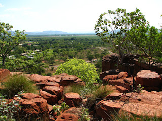
Then we headed back to town (which involved another trip over Ivanhoe Crossing - my turn this time), and drove up "The Knob" - a big rock outcrop rising from one edge of town which offered stunning views over the surrounding countryside. From here we could appreciate all the farming land surrounding the town, supplied by irrigation from the Ord River. We were, again, surprised at how green everything was.
And finally, we headed back to the caravan park and set up camp. Our front yard was a stretch of lush green grass leading to the edge of the lake and a view directly over to "Sleeping Buddha" - another rocky outcrop on the far side. It was a beautiful spot to sit in the shade and watch the antics of the swamp hens. Unfortunately, it was stifling hot inside the tent, and neither of us got much sleep that night.


No comments:
Post a Comment